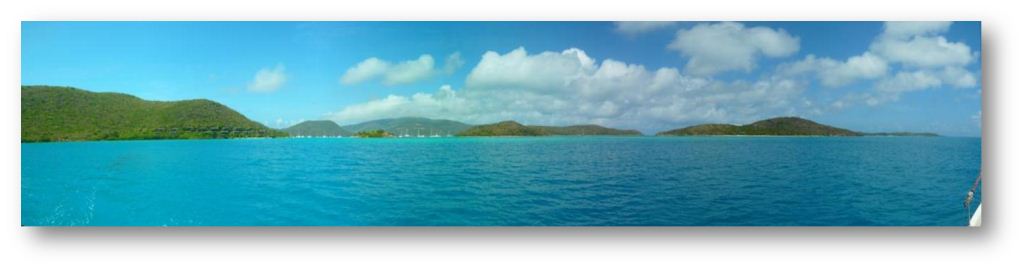
Before jumping into the Big Crossing back to Europe we want to treat ourselves with a last tropical archipelago: the water has never been so transparent than here. Breathtaking landscapes compete with stunning seabottoms. There is no limit to the variety of turquoises that the Sea can display here, between tiny dusts of rocks sprinkled on its surface as some giant maze. This former home of pirates and privateers is like a condensate of the Caribbeans the ideal closure for our island-hopping trip in the Antilles.
(A lot of) pictures and films are on our page "Pictures" and dont complain, we had to cut down drastically on the original stock!
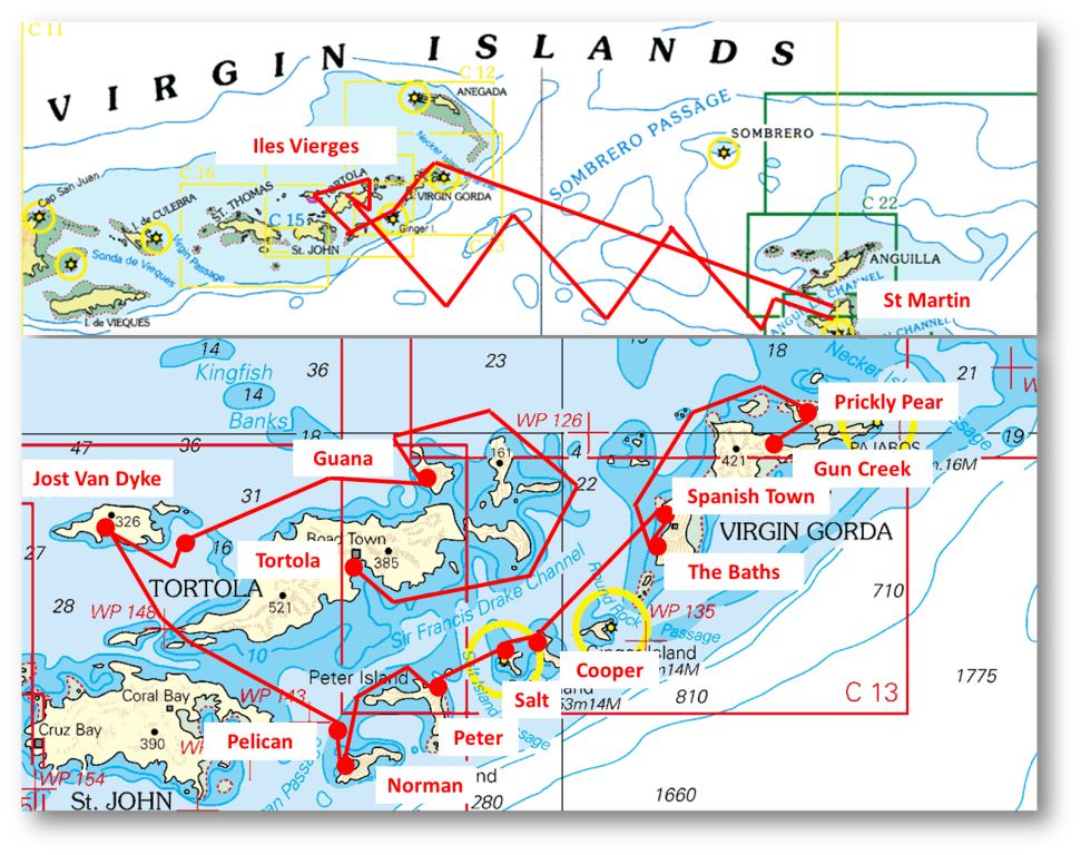
22-23 April 2012 : Grand Case Virgin Gorda (83 M)
We had it all planned and thought through: we had to leave Saint Martin around 5pm to reach the Virgin Islands on the next morning. Yet as we set the sails late this afternoon we begin to fear a night arrival on the following night. The wind is dying out, and pushing us right from the back which means that the wind created by the boats speed comes in perfect opposition to the original wind and makes it seem even less. As long as the sun is up we keep the sails up and spread as a butterflys wings, the main sail kept tight on one side and the pole holding the genoa on the other. In this is highly unstable configuration a human needs to steer. Hence this is not sustainable. Luckily with the night comes some more wind and we can bring the main sail down to ride with the poled genoa only. Our favorite crewmember Bob the windvane is working again and we relax, watching the stars (tonights show is starring the Scorpion and the South Cross!). It feels like the blessed days of the crossing to the Antilles, when we were riding on the trade winds One day well have to accept that this free riding is over and turn back to face the wind yes, but not today :o)
This time we did not have to paint the whole flag, but just the little drawings in the middle, sewed on the good old UK flag.
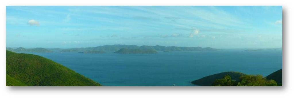
In the next morning we wake up in sight of the Virgin Islands. The archipelago looks beautiful even from the distance we are not the first to think so, as they were named by Columbus (him again), stunned by their beauty, after the 11000 virgins killed by the Huns in Cologne along with Saint Ursula. As an excuse: he needed lots of imagination to name all the Caribbean islands he saw (and sometimes 40 days at sea without a woman can have perverse effects). The free sailing magazine distributed through the Caribbeans, Compass, told us that a new port of entry was open in Gun Creek in the north of Virgin Gorda. This is a perfect location for anyone coming from the east and we made our way passed the north islets (including the very private Necker Island featuring a tiny sandbank bearing two palmtrees in plastic) and into the big bay called North Sound. This huge bay is surrounded by other islands or reefs, so much as to appear like a closed and sheltered lagoon. Anchorages can be seen everywhere, and a couple of marinas: they say he Virgin Islands are a paradise for sailors.
Arriving to North Sound
The « city » of Gun Creek and its brand new customs office !
The particular bay of Gun Creek is almost empty (theres one other yacht anchored there). Easy to find a spot on the east of the ferrys jetty, in 3m of water on sand grounds. Behind the ferry dock is a dinghy dock and next to it, the customs office to check in (1$ for immigration and 12$ for customs). The tiny supermarket on the street carries some fresh products much less now that weve depleted half of their fruit and veggies. Further, nothing. The underwater world is equally average the usual fish, nothing special. The ferries zoom about to and from the other end of the Sound. This is a convenient stop to land in the BVIs and one were happy to leave on the next morning.
24-26 April : anchorages around Virgin Gorda (13 M)
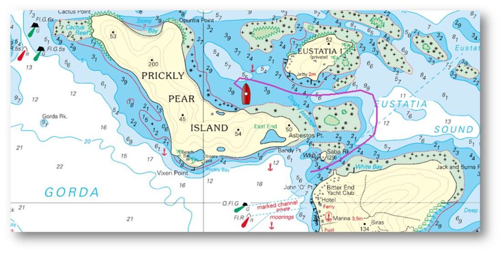
To exit the Sound we decide to try the northern pass between the trendy bar-island Saba Rock and Virgin Island itself. For once we plug in the GPS to display our route real time on the high definition chart. Used along with a good pair of eyes standing on the front railing were ready. The channel is clearly marked until the jetty on Gorda facing the island. Then not anymore and thats right where the tricky part is: you need to keep on straight on the same bearing well after Saba Rock to round the reef behind it, then only turn left to pass by Eustatia. 2.50m depth at the shallowest of the channel. Between Eustatia and Prickly Pear the channel widens until becoming a real bay where a couple of boats are anchored. 4m depth, sand grounds and nothing but nice beaches and clear waters surrounded by coral reefs thatll make a very decent home for one day!
Our route on the chart
Looking from Prickly Pear, Eustatia on the left and Virgin Gorda on the right can you see the pass in the middle ?
One difference with the Grenadines : the coasts are not sand but rocks here
The islands around us look so nice, we cant wait and jump in the dinghy to explore the (almost) empty beaches (to be shared with a couple of catamarans crews others enjoy hidden anchorages as well). Prickly Pear Island where we stand is a natural reserve and there is no building on our side nor a path for that matter. We climb on the rocks from one beach to the next, marveling at the variety of colors and shapes. Theres a little mount on the south of the island, and of course we have to climb on it, making our way as we can through dry bush and shrub. From the top the view on the pass we took in the morning is worth a few scratches!
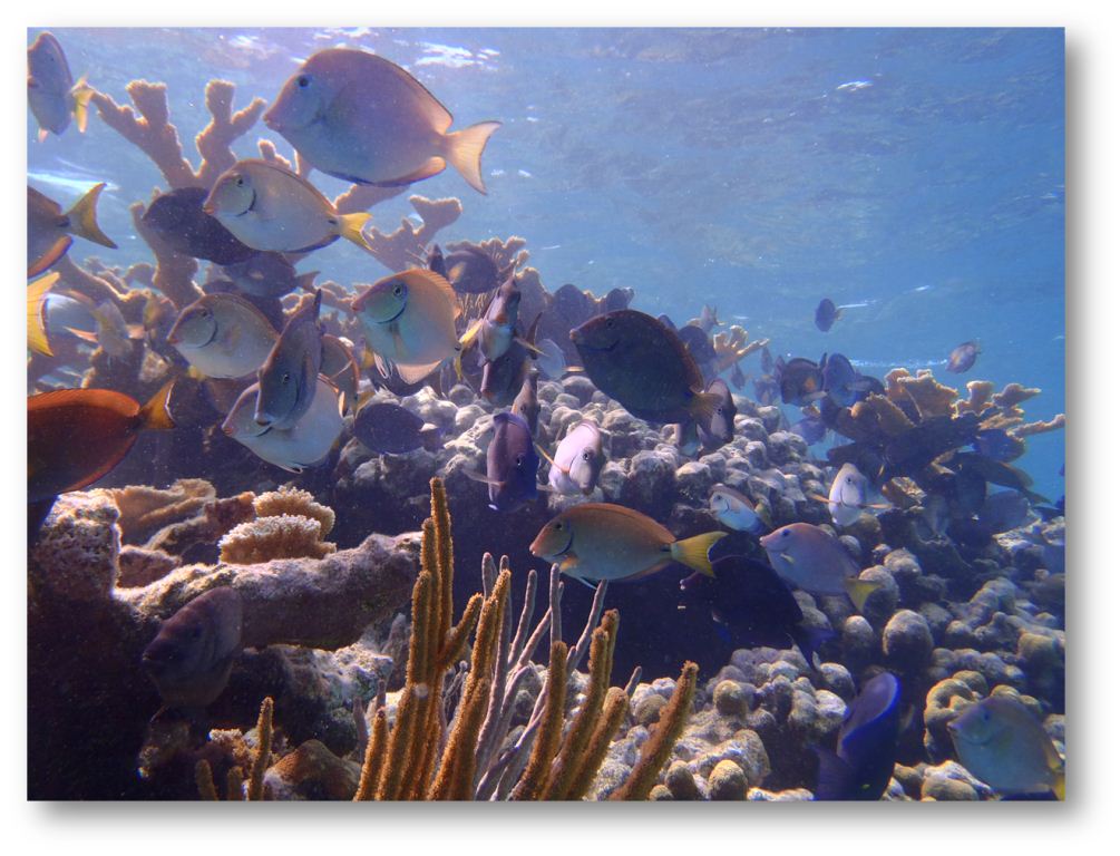
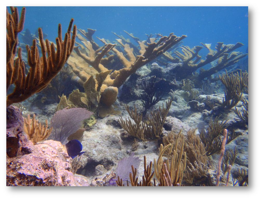
Back onboard: lets go and swim now! The reef closing the anchorage on the north seems promising. With no other weapon but our camera (spearguns are prohibited and any kind of fishing reserved to license-holding island residents) we take a dive and find ourselves flying in wonderland. Probably the most beautiful snorkeling until now. Huge parrotfish, surgeon fish, jewelfish, grunts and the usual suspects make a colorful mess between majestic corals. There are a lot of different sorts of corals here as well, the most distinctive of which, literally named moose horn in French, spreads wide pinky branches to catch the sun. one bad news today: Camilles flippers break apart suddenly after 15 years of faithful service :o( but dont worry, we have a spare pair onboard every critical part we said ;o)
Fishes are not shy: these surgeons are so close that we could reach for them
« Moose horn » coral
After such a perfect day at the anchorage, itll be hard to beat we say to ourselves, sipping our punch under the stars. And yet
Yet on the next morning we emerge from our hiding place through another pass between reefs in the north, to round Virgin Gorda by the west and reach the southern and most famous point: the Baths. There stand huge granite boulders making up a beautiful landscape on the blue sea: beautiful and protected in a natural park. It is not exactly a secret place either, busloads of tourists being trucked there from the capital and the neighbouring islands. In the bay itself anchorage is prohibited, one has to use the (expensive and time-limited) buoys. Less than a mile north though, the next bay is just as beautiful and very welcoming. There is only one big white buoy in the middle and plenty of space to drop the anchor on some sand, well visible through the water which is deep enough very far to the shore. Our anchor bites in nice sand, 4.5m deep. Never seen water so transparent! From the Boat we can see the anchor very clearly, 30m meters in front of us!
Saltimbanque anchored on our dream beach
Through a labyrinth of rocks one can reach « Devils Bay »
We row to shore to avoid capsizing with the dinghy in the steady swell (that makes this almost-perfect anchorage a bit rolly). The swell comes from the south, hitting the Baths as well, and seems to disappear around 10am for some reason. Walking along tiny empty creeks and between huge granite blocks one reaches a last bay before the Baths themselves which we can join only by the road. The Baths and Devils Bay Park is very very busy. Its very very beautiful as well, and we have fun walking and crawling in the caves and under the boulders between the two bays. Yet some hurdle of Italians off their Costa Cruising ship (all with the same green beach towel) spoils a bit of the fun. Under the water though its quieter and the big rocks make beautiful landscapes, all vertical and covered with corals.
Its a short walk to the southern point of the island, where fewer tourists dare to venture on the rocky path. The beach there is far less inviting, with the swell breaking full blast on the rocks it looks like Brittany, but with cactus and lizards everywhere. We leave the park and seek refuge from the crowd on our beloved little beach in the north dont take it wrong but everything looks better without the Italians! We enjoy bathing in blue swimming-pools between the rocks, climbing on them to catch a view A specific beach where the rocks make a kind of sheltered pool is empty, we proclaim it OUR beach ;o) When the time comes to go back home, we promise to come back on the next morning!
Even more beautiful when its only for us :o)
Our swimmingpool on the right hand side, the popular anchorage of the Baths on the left
The natural swimming pool of our beach we found the tropical Eden
In the morning a big barracuda is circling around the boat, a clear sign that we have to start the day onshore! We land on the beach wearing nothing more than a swimming suit and a tshirt against the sun. The landscape is just as stunning as the day before, theres no getting tired of it. At 8am the sun is hot already and we swim a little. A few rocks to climb, then we make our way for our swimming pool Surprise, some suicidal guy in a heavy-powered small plastic boat is trying to ride above the rocks into the pool, roaring his 115 hp and bumping around Once inside he drops about 20 beach unbrellas and a BBQ kit on the beach, which turns out to have been rented for the day by the crew of some luxury motorboat. Never mind, theres a wide choice of empty creeks here and nobody will come disturb us in the next little pool!
Its not a long stop back onboard, just the time to grab our snorkeling gears and back to the water we jump! The granite boulders are less impressive on that northern side of the anchorage than in the Baths, but the fish are always lots of fun :o) we spend some time studying a weird little shell clinging to a coral leaf, which gets out of its own shell to cover it entirely.
On the left, normal state : the little beast covers its own shell. On the right, its scared and hiding in the shell.
The view out of our window today
Our body might be in Spanish Town, our mind is still playing on the big round rocks
We are still two boats only anchored by our dream-beach and theres no motivation to leave but we have nothing left to eat and our next article is already 15 days overdue: we need a town. 1M further north lies Spanish Town, the main city on Virgin Gorda. We anchor just north of the ferry channel, just outside the beacons and by the rocks, in 3m of water on a nice sand ground. The little beach there makes it easy to land. We are looking for the city centre, hoping to find shops there. 30 minutes later we have located the marina, 3 ATMs, 2 churches and got lost in the fields around the twon. Funny how they grow things here like in Europe: everything neatly planted in rows, standing on stakes and covered with plastic. Where are the wild bananas/mangoes/canes chaos? In the end e end up in the marinas supermarket and spend 95$ on groceries gloops! Thanks to yachting industry and offshore companies registration the BVIs enjoy a GDP per capita higher than the US, the UK and Sweden and the price of the beer at the internet spot is a good indicator of this! Theres no little producer here selling away their gardens production of mangoes as in the rest of the Caribbeans. Fruits are apples imported from Holland, or oranges from Nicaragua, all frozen as an unmistakable sign of civilization :oS At the bar next door we find wifi to get our weekly fix of emails and mosquito bites good, were all set to head for another week of wild anchorages now !
27 - 28 April : exploring the south islands (16 M)
In the morning we leave Virgin Gorda (= the Fat Virgin) and head for the smaller islands in the south. Its nice to sail around here in the middle of the archipelago, theres always some surprising perspective or some unsuspected pass opening as we progress. All the islands are rather high (150 to 500m) and their steep slopes give away their old volcanic origin. The granite and basaltic rocks have been nicely shaped by erosion and covered with a dry vegetation. One exception to the pattern: Anegada in the north, where we wont go this time, is a flat sand bank, essentially just a coral reef very much like Barbuda.
The little Virgins on our portside
First stop by Cooper Island next to this rock
Our first stop of the day is off Cooper Island at a reputed snorkeling spot. Its only a couple of miles to sail pushed by a nice breeze with nothing but the genoa up. A little dolphin makes some jumps around before going away again, before we enter in Mancheneel Bay. The Mooring company set up so many buoys here that theres no space left to anchor and we take a buoy for a few hours, at the very southern end of the bay, next to the snorkeling spot.
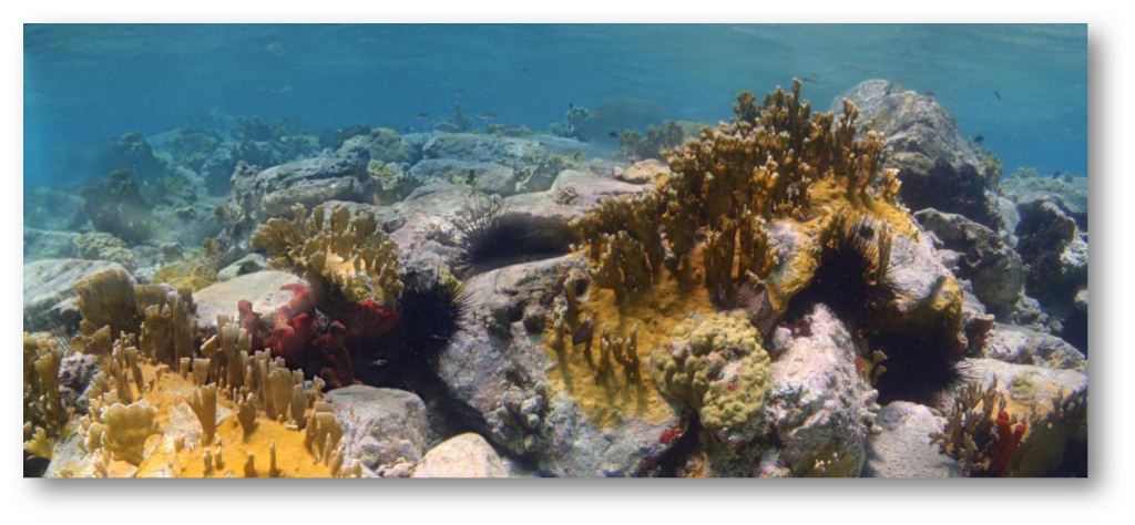
The first thing we see under the water are huge tarpons around the boat not very reassuring with their big teeth and angry looks. Next to the rock the snorkeling is wonderful. Lots of corals of all kinds and big fish, friendly and curious as they have never seen a speargun. Snappers and Grunts and Surgeons and Parrotfish and Jackfish and a lobster so big that we could have had two good meals on it!
A nasty-looking tarpon
A nice-looking Filefish
On the way back to the boat we almost run into a 1.50m tarpon, takking us by surprise we make a quick turn only to realize that were facing a barracuda nearly as big brrrr, were happy when were safe on the deck. (Theyre not supposed to be dangerous, but they have impressive teeth). Its time to head for the next island, Salt Island, 1 mile further west.
Panoramic pictures under the water, pretty amazing !
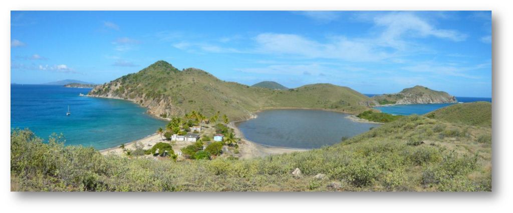
The anchorage on the north of Salt Island is by no mean sheltered from the swell, nor from the wind. For a couple of hours though its okay, just the time to briefly explore the shore. Our daily routine in the BVIs is pretty simple: one snorkeling a day for Laure, and one hike for Camille in any order good program isnt it! So we are landing on this tiny rock of an island, on the beach where a couple of abandoned houses are standing as a memory of the family that used to live here working on the salt ponds. Theres no other boat, nobody else around, the island looks wild and desert. A few goats are roaming around, turned back to the wilderness. After the houses and from the hills the view is just amazing. Shades of blue of the sea contrast with the pinkish brown and green of the salt ponds. Just magic!!
Salt Island : a lonely Saltimbanque in a colorful picture
Back on the beach we find a little patch with stones, which turns out to be an old cemetery, with 9 rough tombs of stones and coral. One tomb is decorated with a wooden cross falling apart, another with a lambi shell. A moving memory of those who used to live here.
Saltimbanque at the anchorage in the beautiful Deadmans Bay
On the next island again we find a good shelter for the night. Its Peter Island, home of the very private Peter Island Resort (where moorings cost 65$/night as well hear later). We find the perfect anchoring spot in Deadmans Bay, an empty beach of beautiful sand ground. Its a name of some pirates hide-away certainly. As a matter of fact, the hundreds of little creeks and narrows passes have made of the BVIs the ideal shelter for pirates, booty-hunters and privateers for centuries. English, French, Dutch, Danish (Danish? Not part of the usual suspects!) fought over these islands ideally located on the way back home of the heavy gold-loaded Spanish galleons. The English ended up with the eastern islands, the Danish with the western islands, which they sold back to the US in the end. Sir Drake, Hawkins and many others were popular figures around here.
First thing the next morning we start by a little hike around the island. A dust road makes a nice loop about the eastern hills and down to the southern point of Peter Island, and is thoughtfully equipped with banks to rest every now and then and with fresh water tanks! (Little paper cups are provided!). Its a beautiful walk with some stunning views around except when we got lost on the wrong track and found accidentally the islands landfill where they burn away their garbage. Thats the flipside of paradise
Cool water tanks on the way, courtesy of the Peter Island Resort
A few on some Virgin Islands
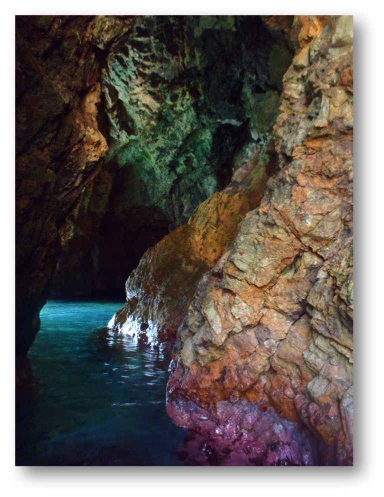
One of the 3 caves of the « Treasure Island »
Walking: done. Now time to swim! We head for the next island, Norman Island, also known as the Treasure Island depicted by Stevenson. Hes said to have learnt from his sea-faring uncle the location of some Spanish gold treasure hidden in this islands caves. The caves are accessible only by sea and are one of the most famous places in the BVIs now, well equipped with moorings. There seem to be two systems of buoys in the BVIs: the colored buoys (red for snorkeling up to 90 min, yellow for commercial crafts, blue for dinghies) are kept by the Natural Parks to avoid damaging corals. The white buoys can be found all over every good bay and belong to the Mooring Company which charge 25$/night. Their presence everywhere is a good incentive to improve our skills in precise anchoring maneuvers (anchoring between or next to them is always allowed but not always easy).
So we pick a red buoy this time and swim to the caves. In addition to the usual big fishes and colorful corals we enjoy swimming in the middle of thousands little silver fishes as we enter the caves. They are quite shallow and well lit, shining of magnificent pink and orange colors all around their walls. Nice!
A huge bunch of litltle fish just outside a cave.
Behind the land head we can find a good spot for the night: the Bight, a legendary pirates hole - now more of a charter boats hole, all aligned on their white buoys. On the northern edge of the bay we find a little free space, on sand by 6m depth. Laure makes use of her favorite check the anchor excuse to swim to the coral reefs along the beach.
A few miles away from Norman Island, there stand a bunch of rocks, called the Pelican and the Indians. Who can resist such an exotic name? So here we are, early in the morning on a red buoy between the big bird and its feathery friends. The snorkeling here is just magical, by far our best dive of the trip! Right under the boat are purple and pink corals, a bit further it looks like a colors contest: which rock can display most different species on one square meter? Behind one of these rocks, the sea gets deeper and the waves break, perfect conditions for thousands of fishes. It´s a festival of doctor fishes, parrot fishes, jack fishes, friendly triggerfishes all dancing around us. The star of the show may be this huge tuna, or the black Durgeons, or would it rather be the Queen Angelfish?
Diving by the Indians
Little Thatch passage
What a nice swim but it´s time to leave again and we furl the sail out (yes indeed, still using the genoa only, it´s not so elegant but really comfortable) and go on sailing in the United States :o) A short passage in US Virgin Islands waters just nearby, before we round Tortola through the Little Thatch pass and land in Jost Van Dyke.
The sheer name of this island attracted us here. This was the home of the namesake Dutch pirate in the 17th century. Now there are only 200 inhabitants (and electricity lines since 1991!), all gathered around the Main Street - actually just the edge of the beach. We try first to anchor in Little Harbour but it was poorly sheltered and full of buoys. Finally we anchor between the buoys at Great Harbour. Several trials are necessary to find a big enough spot, by 5m water on a medium quality sand. There are about 30 boats in the bay, including one ketch on her anchor and two Norwegian boats on buoys. The rest is a very representative mix of rental boats, monohulls and catamarans, all either from Moorings or Sunsails. Saltimbanque looks like an alien (we are by far the smallest boat of the whole archipelago)
Where is Saltimbanque? It´s the smallest boat of the bay !
To enjoy the last rays of sun we climb up the summit of the island to admire the view. We have now reached the most western end of our trip: 64W45 exactly! Its been a while since we left Holland, by 4E25! Back in the bay we decide to celebrate with a drink at the famous Foxys bar. As we were working on our Pain Killer drink ( rum, pineapple, coco, orange), a Canadian lady on vacations for a week on the rental motor catamaran side to us starts chatting with us: she asks where we are coming from and what the hell we are doing on such a small boat. She seems impressed by our answers, whishes us a nice evening and comes back a few minutes later: her husband and friends cannot believe that we came from so far away, they invite us to join them for dinner to hear more stories of our adventures !!
Just there, the USA ! (Or close enough, the US Virgin Islands actually)
On the day after, theres no choice left but to head to the East i.e. against the wind. The genoa is replaced by the smaller gib, and we take the first reef to reach the small island of Sandy Cay, just a few miles away from Jost Van Dyke. As usual, we pick up a red buoy, small snorkeling and the fatal mistake: the walk onshore A few trees grow on this small piece of land, enough to be the home of extensive mosquito tribes, very thirsty and aggressive: they followed us even in the water and left us scratching memories for a few days!
Saltimbanque at Sandy Cay
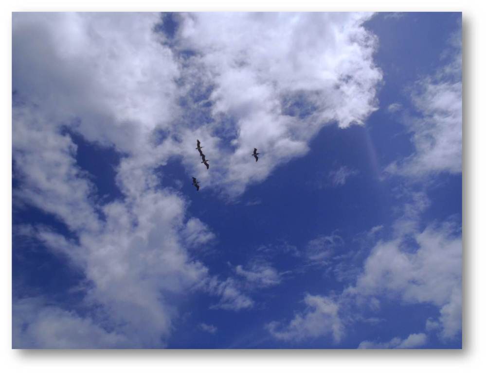
Pelican flight
Heading again to the East, we train for our everyday life on the Atlantic crossing and make two long tacks to reach the next island, Guana island, named after the conspicuous rock looking like an Iguana. On the western coast we find a long sandy beach (and only a few buoys) which seems just perfect for an easy and sheltered anchorage. Well, not exactly :oS Through the clear water we can count the rocks on the ground, everywhere up to the beach itself ! After many tours and hesitations we drop he anchor in the exact middle of a 2m long sandy patch. Just below the sand is a rocky shelf and the anchor does not hold very well, but with our 30m of chain in 3,7m of water, that should do the job! At last an anchorage for travelling boats; we spend the rest of the afternoon swimming with the fishes, in particular a few lion fishes, these new invaders of the Antilles with nice but poisonous stings. A huge tarpon let us understand that its time to get back onboard.
Under the stars this evening we celebrate our anniversary: its been exactly a year that we have stopped working!
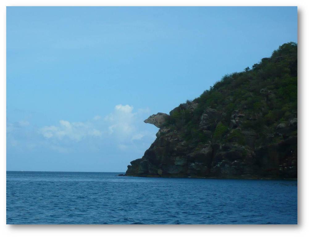
The famous iguana head
1st May : Guana Island - Tortola (20 M)
This morning is our last day in crystal clear water before the crossing (or so ze believe at the time): we clean the hull which starts to get a bit green already, only a month after painting it. Once the work done we set the sails: 10 miles close hold to the wind to round the north point of Guana Island and the east point of Tortola, then 10 miles with the wind to the beam to quarter back in weird choppy seas (due to tidal currents?) to reach the BVIs main harbour, Road Town. The wide bay there is busy with marinas, cruising ships, oil terminals, dockyards... all signs that make a good base to get ready before a long trip. At the very end of the bay two breakwaters protect two marinas and a tiny place by an isolated patch of surviving mangrove where anchorage is supposedly tolerated. We smile at the couple of other travel boats anchored there, between the posh marina and the rental boats base. 6m deep, soft mud: exactly what our anchor doesnt like and we drag it at the first attempt (just as we were about to go to shore - always watch the holding for longer than youd think necessary). We try again just a few meters further and this time it holds. No way we move now, even though the guard on duty at the marina says we are in the channel (what channel? Theres no buoy!) and threatens to send the cops and send all the travel boats with their used sailed and tarnished paint away from his shiny pontoons. Yet we stay onboard and keep an eye on the anchorage while working on some small prep work (tiny UV-holes on the sails, cleaning Nestor, setting the right ropes at the right place for the crossing )
Well, with such conditions our speed will be everything but fast !
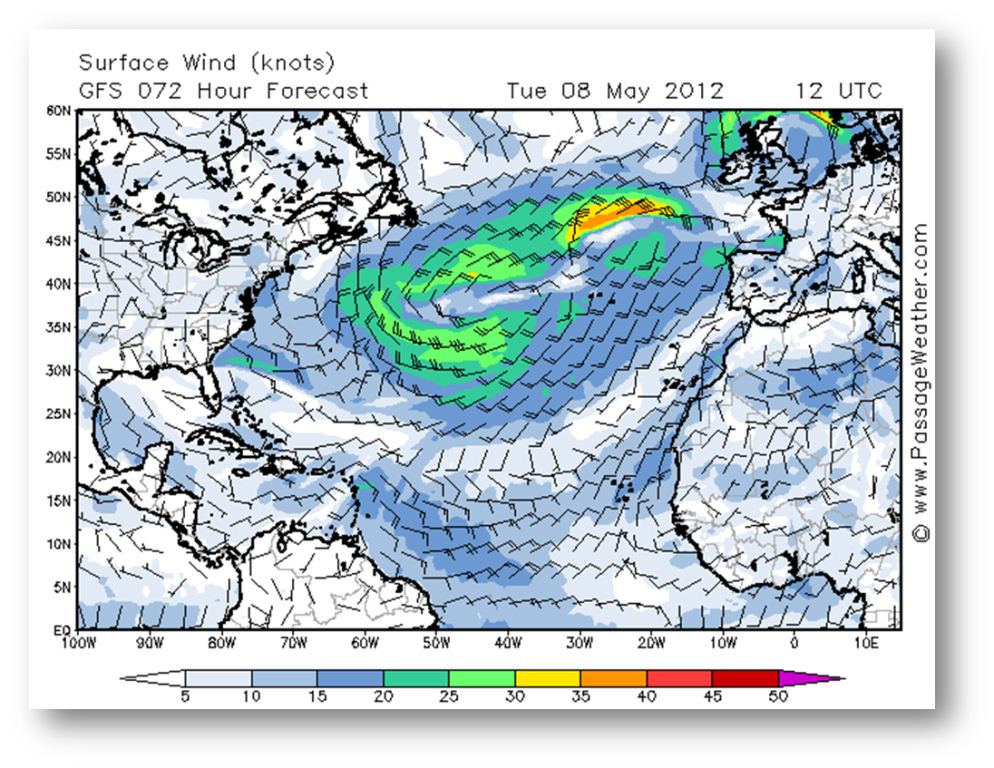
On the next day we start working through our to-do list, full of enthusiasm: the supermarket and fresh water supply are located, the laundry dropped by the cheapest Laundromat ever (2$!), we are sitting with a coffee checking the weather forecasts hey, why are the charts all white? Wheres the wind??? In two days the wind is supposed to die to virtually nothing and remain so for the rest of the week. The usual high pressures of the Azores have decided to take some holidays down to the Cape Verdes (we dont blame them), leaving their seat to a big stationary low that kills the trade winds. Just about the opposite of the normal wind pattern: the north of the Antilles will experience something similar to the doldrums in the next days. If we were to leave now, we would have to start by motoring for 3 to 4 days and use up most of our fuel right away. This is not an option. The only alternative we can think of is to quickly sail off with the last two days of wind and go to Saint Martin again, thats already 80 miles gained to the east
We clear out and quickly buy some food under a pouring rain, then at 3pm were gone. Sailing against the wind, away from our tropical paradise the holidays are really over now!
2-4 May : Tortola Saint-Martin (150 M)
Looking at the charts we could expect nothing better than a dying wind and a humid, grey sky. We take it as a good training for the first days of the crossing.
The first miles are not that bad though, with the main sail up and the gib Saltimbanque makes the most of the little wind, in a grey but dry weather. We squeeze in between Salt and Peter islands, remembering our nice walks there The channel is wide enough, except for an isolated rock right in the middle, the Blond rock: if you hit this one, then you are really blond! Ok, we had to tack to be sure as the sun turns your hair very clear indeed Serious things start with the night: lightning striking everywhere, squalls growing up in front of us, on the back, on the side we have to tack to avoid the biggest one, and even bear away and lose some miles as we sail at 6.5 kts as far as possible from the cloudy mass. Lightning, thunder, it struck 2 miles and a half behind us, well done
Last view of the Virgin Islands nice weather for the season !
The end of the night and the next morning are quieter and we manage to have some rest. But the wind drops more and more, and against the oceanic current flowing to the west, we make bad tacks at 3 knots only The squalls growing up, finally killing the smooth breeze, before spitting it back in every direction in wet and electric gusts. Generally we manage to squeeze in between the biggest clouds by multiplying the tacks. But at night fall, nothing to be done: the sky is dark black ahead of us without any obvious escape door. The wind picks up so much that we keep only a very small bit of genoa and leave side wind to the north at more than 6 knots. We are now in thunderstorm mode: all the electric is down and we are safe inside the Faraday cage, only checking outside from time to time for cargo ships and the lightning. The closest strikes about 1,8M just ahead of us The strongest part of the squall lasts only 45 minutes, but we have lost more than 3 hours in this story. Our morale is not very high as we call for Nestor to help us in the dying wind after the squall, the strongest one since South America
Finally after hours of wind exhaustingly changing from 6b to dead calm, the only constant parameter is the rain. We arrive quite tired at Marigots anchorage at 5am, after a few hour cheating and called Nestor for the last miles. The hook falls on a lake by 3m of water, just outside the area of anchorage and we collapse on our bunks as the first ray of light start emerging on the East.
4-8 May : in the starting-blocks in Saint-Martin (again !)
It's already late in the morning when we get up under a warm sun. in the daylight we can see the other boats and squeeze in to anchor closer to the dinghy dock. Theres a change to be felt in the air since our last stop here 2 weeks ago. Many travel boats are gathering now to this traditional starting point, all about to cross back. Ster-Vraz is leaving 2 hours later, hoping to sail their little Rush in the feeble breeze. Ann Tarz, Phileas, Beltza and so many others are here as well: additional oil tanks are packed on the decks and theres one favorite topic on every mind: where are the high pressures gone?
As for us we have still a few things to do: cleaning, changing the oil of the outboard engine, putting some order in the boat and buying lots of fresh food. And of course writing on the blog, and checking the charts to understand where the winds have gone That's for the serious part of the days. Lots of time off is spent in chitchats and visits to neighbors, as well as emptying the dinghy (we got 91L of rain in it last night !). We can even listen to the results of the presidential elections live - after all, we're (almost) in France... Almost: no movement comes to stir the sleepy city as the scores are anounced, there's nobody in the street and all the bars are closed.... A few hours later we see a couple of cars driving and honking around, waving purple (?? Thought socialist flag was pink??) flags. They show big pictures of an unknown guy with thick dark hair and tiny moustache, looking very latino. A loud sound system is playing music and calls in Spanish. Something very important must have happened... in Dominican Republic!
Theres a nice little South West breeze indeed but 800 miles away in flat calm !
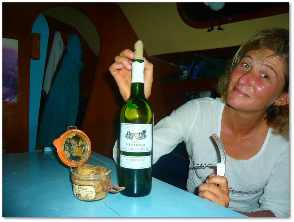
This is it, Laure has also turned 30 now !
The charts are promising some kind of a trade wind back on Tuesday morning. That leaves us a day to get some fresh food, water - and a good meal to celebrate Laure's birthday. For her 30th birthday, we started with a pizza for lunch, and continued with a nice dinner onboard: home made lobster paté from St-Kitts, cinnamon chicken, and of course coconut pie, accompanied with a good white wine from the Bordeaux area !
The crossing back to the Azores will be long and tricky (weather conditions can change and must be carefully anticipated) As during our first crossing we will very much enjoy messages from the shore on our Iridium phone!
SuDad - 28/05/2012 12:20:17 Pas trop vite, SVP. Qu'on puisse encore rêver. Bien sûr, l'océan, les grains, la houle, les quarts, c'est sympa aussi (sauf pour vous), c'est un autre scénario. Mais vos dernières escales parfumées et bariolées, les "jets d'ancre", les poissons, quels délices. Nous aussi, on rentre à reculons, là. Même si de nouvelles aventures attendent encore. Elles seront un peu plus fraîches. Mais vous saurez nous les animer. Vous allez toucher les Açores, en ayant encore brûlé les vagues, avec pas mal de jours d'avance. A ce train-là, vous ne voulez pas refaire un tour ? Merci de toutes ces couleurs. Nous vous embrassons. Eric et Sandrine - 13/05/2012 22:24:17 N'allez pas trop vite les filles, on va avoir du mal a vous rattraper... :) Départ le 23. saltimbanque par iridium - 13/05/2012 17:45:17 13/05 14UTC 24N32 58W27 CAP 40 5NDS VENT 15/25NDS SE.TVB,MOINS D'ORAGE,REPASSÉ TROPIQUE CANCER!MER RAFRAICHIT!BISOUS
Hans en Remco - 13/05/2012 09:04:17 Wow ziet er mooi uit hoor, nu weer een lange trip voor de boeg, sterkte, hou je taai saltimbanque par iridium - 11/05/2012 19:31:58 SALUT LA TERRE.11/05 17UTC 21N09 60W26.TVB,CALÉES SUR LONG BORD DE PRES,ON APPREND VIE PENCHÉE!SOLEIL JOUR,ECLAIRS NUIT.BISOUS!
Marie Leroy - 10/05/2012 23:15:53 Olà raparigas!
Avant tout, je souhaite m'excuser auprès de Camille pour avoir oublié son anniversaire. Jamais ça ne m'était arrivé avant...
J'ai honte!
En tout cas, je suis une lectrice assidue... Je dévore vos récits depuis le début !!!
Vos photos sont magnifiques ! Et votre bronzage alors : WOW, je suis super jalouse...
Até breve (à bientôt)! ;-)
Beijinhos, Maria-Cristina Nadia - 09/05/2012 14:41:03 merci de nous faire voyager avec ces photos et videos sublimes ...
j'aime la piscine " à droite" ;-)))))
Bonne continuation ! Dick - 07/05/2012 23:54:29 Gave trip! Hier wil het maar geen lente worden ik bereid wat weekends naar Engeland en verder voor. Nieuwe VHF extra gps en zo. Veel plezier jullie en stay safe! la mamou - 07/05/2012 22:01:09 je reviens de votre album photo : les baths c'est du pur kerlouan !!
vos photos sous marines sont de véritables oeuvres d'art !! la mamou - 07/05/2012 21:37:31 en effet , les vierges sont belles , presqu'autant que ma bretagne nord ... mais bien moins grandioses quand même !!... :-)
Sylvia - 07/05/2012 21:36:38 Gefeliciteerd met je verjaardag! Dit wordt een spannend nieuw levensjaar voor je. Ik ben benieuwd wat het gaat brengen. En ik weet zeker, dat alles goed komt. Geniet ervan. Veilige reis toegewenst.